
CASTLEGAR – The BC Wildfire Service continues to respond to the N51257 wildfire in the Mount Rollins area. This wildfire is estimated to be 236 hectares and is suspected to be lightning-caused.
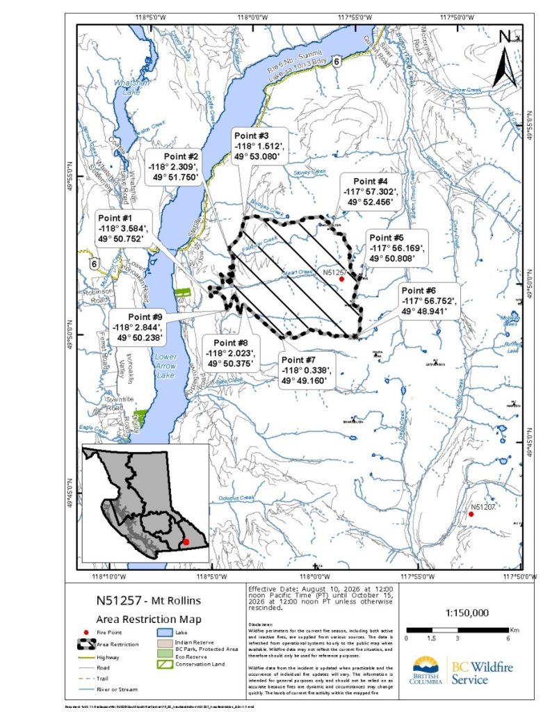
In the interest of public safety, this area restriction is effective immediately and remains in place until the earlier of 12:00 noon (PDT) on October 15, 2026, or until the Order is rescinded. This Order applies to Crown land within the geographic boundaries described below and as outlined on the attached map.
This Order applies to Crown land within the geographic boundaries described below:
- Commencing at Junction of Road Permit APPLEGROVE ROAD/BR 2 and Road Permit SECTION TWO at Point #1 (49° 50.752′, (-118° 3.584′)
- Follow Road Permit SECTION TWO to the North as it becomes Road Permit PIN ROAD and continues Northeast to the junction of Road Permit PIN ROAD, Road Permit SECTION ONE and Road Permit SECTION ONE C at Point #2 (49° 51.750′, -118° 2.309′)
- Follow Road Permit SECTION ONE C to the North to Point #3 (49° 53.080′, -118° 1.512′) a point along the road
- Following the height of land East to Point #4 (49° 52.456′, -117° 57.302′)
- Continue along the height of land Southeast to Point #5 (49° 50.808′, -117° 56.169′)
- Follow the height of land South the Point #6 (49° 48.941′, -117° 56.752′)
- Follow the height of land West to Point #7 (49° 49.160′, -118° 0.338′)
- Take a bearing of 318 degrees for 1.63 kilometres Northwest to the end of Road Permit SECTION TWO F TWO at Point #8 (49° 50.375′, -118° 2.023′)
- Follow Road Permit SECTION TWO F TWO to the West to the junction of Road Permit SECTION TWO F and Road Permit SECTION TWO at Point #9 (49° 50.238′, -118° 2.844′)
- Follow Road Permit SECTION TWO to the Northwest back to the point of commencement.
A detailed map of the affected area is available below:
Under this Order and section 11(2) of the Wildfire Act, a person must not remain in or enter the restricted area without the prior written authorization of an official designated for the purposes of the Wildfire Act, unless the person:
Enters the area only in the course of:
- Travelling to or from his or her principal residence, that is not under evacuation an order;
- Using a highway as defined in the Highway Act;
- Travelling as a person acting in an official capacity as defined in s.56 of the Wildfire Act;
- Travelling for the purpose of supporting wildfire suppression or enforcement patrol activities.
Failure to comply with Section 11 restricted area requirements may result in a violation ticket for $1,150.
Road closures and area restrictions are subject to change depending on fire activity. For the most current information please visit the fire prohibitions and restrictions section of the BC Wildfire website for the Southeast Fire Centre.
The Southeast Fire Centre extends from the U.S. border in the south to Mica Dam in the north, and from the Okanagan Highlands and Monashee Mountains in the west, to the B.C.-Alberta border in the east.
Report a wildfire
The Southeast Fire Centre would like to thank the public for its continuing help in preventing wildfires.
You can report a wildfire, unattended campfire, or open burning violation by:
- Dialing *5555 on a cell phone
- Calling 1 800 663-5555 toll-free
- Reporting through the BC Wildfire App Report a fire function
- Reporting through the app lets you upload images and can be used without service.
Stay up to date with the latest wildfire news on:
- BCWildfire.ca
- BC Wildfire Map
- BC Wildfire App: Apple or Android
- Facebook and Instagram
Contact:
Fire Information Team
BC Wildfire Service
Southeast Fire Centre
250 318-7715
Connect with the Province of B.C. at www.gov.bc.ca/connect