
After a summer of elevated wildfire hazard and activity across southern B.C., rain and cooler temperatures in late August and early September moderated fire behaviour, assisting firefighters with initial attack response and progress on currently burning wildfires.
Entering into fall, warmer and drier-than-normal conditions are expected. There is potential for higher-than-normal fire activity later this fall, as well as warm, dry overwinter conditions that could affect existing drought and snowpack levels.
Hear more from Superintendent of Predictive Services, Neal McLoughlin:
Recent conditions and fire activity
With underlying drought and warm, dry conditions across the B.C. Interior, fire activity peaked in July and August with an elevated number of new starts and vigorous, difficult-to-control wildfires. While recent precipitation has helped dampen fire behaviour and allowed crews to make progress on their objectives, fire activity continues and underlying drought concerns remain on the landscape across southern B.C.
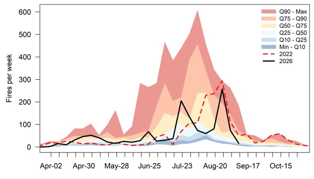
Several regions of B.C. entered the summer of 2026 with above average drought conditions, including the Chilcotin, Lower Thompson, Okanagan, Vancouver Island and northeast. Read more in the Summer 2026 seasonal outlook.
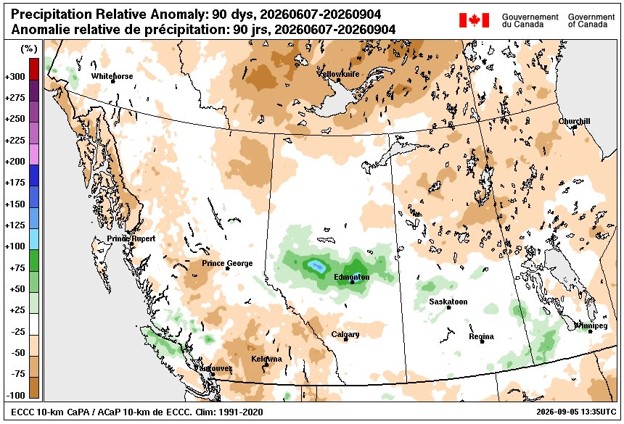
The months of June through August were anomalously dry with a lack of precipitation across a majority of the province, including the regions which entered the summer with above average drought. The lack of precipitation contributed to very dry fuels highly susceptible to ignition and spread.
From June through August, the total number of lightning strikes was lower-than-usual, at 73 per cent of the 20-year average. Even with reduced lightning, 62 per cent of the 1,413 wildfire starts this year are lightning caused. The proportion of lightning strikes causing fires in 2026 is comparable and even higher than some years with above average lightning activity, underscoring the underlying drought conditions on the landscape.
Fall forecast
While late summer rain across the Central and Southern Interior has dampened fire behaviour, continued drought and warm, dry conditions are expected to fuel higher-than-normal fire activity this fall. Warm and dry conditions fueled byEl Niño could affect snowfall accumulation and drought over the winter months and into the 2027 fire season.
Fall brings a decrease in convective thunderstorms and lightning, shorter daylengths and generally cooler temperatures, better overnight recoveries and increased precipitation. These weather factors help decrease fire activity and the potential for new starts.
Late summer rains have helped dampen fire behaviour in early fall 2026 and contributed to drought recovery on the South Coast and Vancouver Island. However, the month of August was warmer and drier-than-normal across the Central and Southern Interior and the far northeast. In areas of B.C. experiencing drought, rainfall amounts are 40 to 60 mm below the average accumulated rainfall for this time of year.
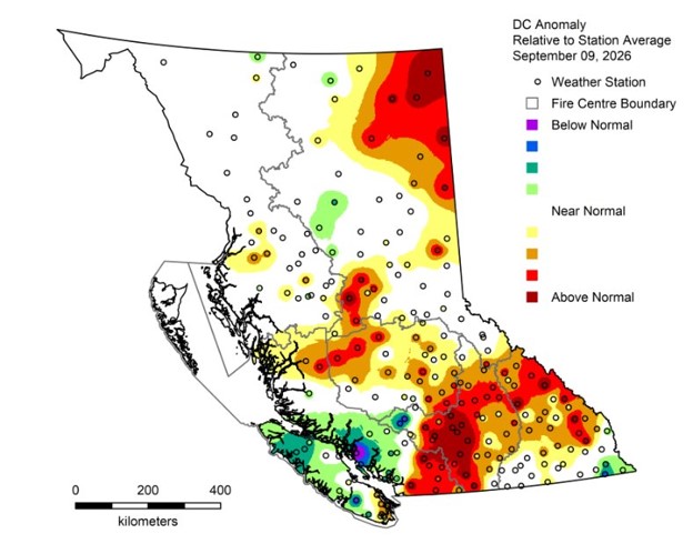
Above-average temperatures and drier-than-normal conditions are probable through September for northern B.C., the South Coast and parts of the Interior. Drought conditions also remain above average in the Kootenay, Thompson, Okanagan, Cariboo and northeast regions of B.C. Although the conditions may allow fires to start more easily than in other recent fall seasons, the fire behaviour will not be as elevated as in summer months.
With an El Niño event intensifying, temperatures in the northern Pacific Ocean are forecast to be two to five degrees warmer than average moving into the fall and winter. El Niño is the warm phase of the El Niño-Southern Oscillation, a weather pattern resulting from changes in ocean temperature in the equatorial waters of the Pacific Ocean. While El Niño does not appear to have an effect on temperature patterns during the summer fire season in B.C., in late fall and winter it could bring warm and dry weather to the Interior, more precipitation for coastal regions and lower winter snowpacks.
Long-range guidance indicates that B.C. will see a warmer-than-normal fall with below normal precipitation, a low winter snowpack in interior regions and low likelihood that regions experiencing above normal drought this fall will recover ahead of the 2027 fire season. Coastal regions may fare better, with more overwinter precipitation.
Snowpack is one means of forecasting an early or late start to the fire season. A healthy snowpack covers forest fuels, especially in the high alpine and at ridgetop where lightning tends to strike. When snowpack melts, it helps elevate moisture in forest fuels. Low snowpack and underlying drought are a concern for the spring and summer of 2027. However, it remains to be seen how other relevant weather factors that help determine the severity of the fire season, namely precipitation levels and drying patterns into summer months, will materialize.
Summary
While the shift into a fall weather pattern has helped dampen wildfire starts and activity on currently burning wildfires, pre-existing drought and warm, dry weather could contribute to increased fire activity later this fall. With El Niño intensifying over the winter, coastal regions may see more precipitation while interior regions could see warm, dry conditions and a low winter snowpack as well as a low likelihood that regions experiencing drought will recover ahead of the 2027 fire season.
Do your part and stay informed about the current wildfire situation
- Download the BC Wildfire Service app
- Follow us on Facebook and Instagram
- Watch our YouTube for wildfire updates and information