KAMLOOPS – The BC Wildfire Service has implemented an Area Restriction Order in the vicinity of Casper Creek wildfire (K71535), which originated approximately 24 kilometres west of Lillooet on the north side of Seton and Anderson lakes.
This area restriction reflects the need to protect the public and BC Wildfire Service personnel in areas where fire suppression activities are taking place.
This Order takes effect at 12 p.m. (noon) Pacific Daylight Time (PDT) on Sept. 8, 2023, and remains in force until the earlier of 12 p.m. (noon) PDT on Sept. 15, 2023, or until the Order is rescinded.
Under this Order and section 11(2) of the Wildfire Act, a person must not remain in or enter the restricted area unless the person is:
- Travelling as a person acting in an official capacity;
- Travelling for the purpose of supporting wildfire suppression activities;
- Travelling to or from his or her principal residence, that is not under an evacuation order;
- Travelling to or from his or her private or leased property for the purposes of accessing his or her secondary residence or recreational property, that is not under an evacuation order;
- Using a highway as defined in the Highway Act; or
- BC Hydro employees and contractors engaging and/or participating in necessary maintenance of the Terzaghi Dam and the BC Hydro Bridge River Penstocks.
This Order applies to Crown land within the geographic boundaries described below and as outlined in the heavy black dashed and shaded grey line on the map located here.
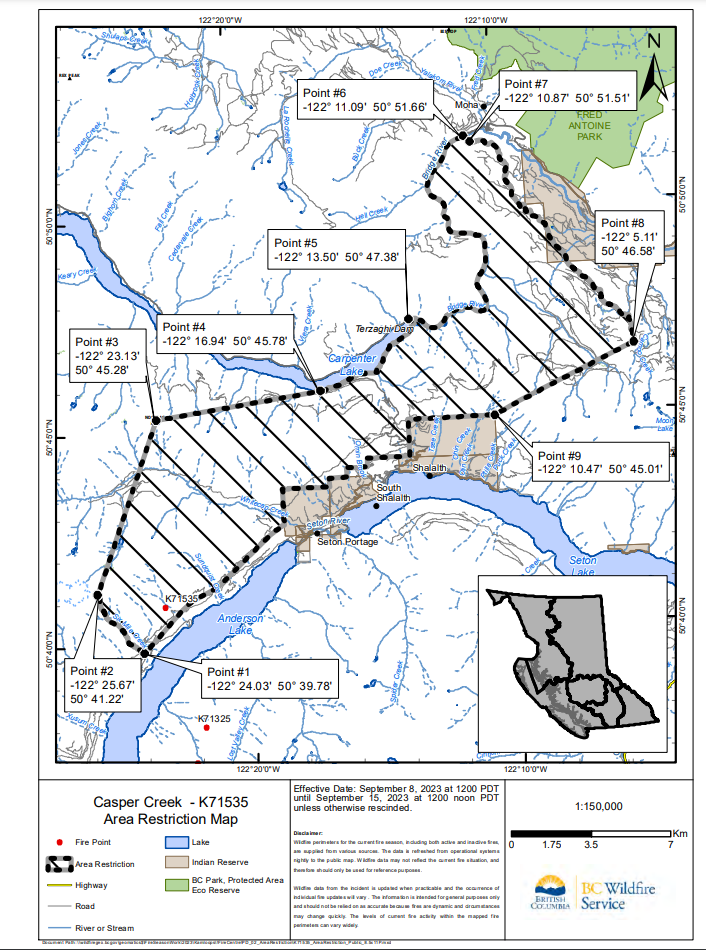
West Boundary: Commencing at Point 1 (50° 39.78’, -122° 24.03′), at the intersection of Six Mile Creek and the western edge of survey parcel 6340550 (BC Hydro Transmission line), travel west along Six Mile Creek to confluence of Six Mile Creek and unnamed tributary (Point #2: 50° 41.22′, -122° 25.67′).
North Boundary: Commencing at Point 2, take a bearing of 21.38° and travel 8.1 km to the summit of Nosebag Mountain (Point #3: 50° 45.28′, -122° 23.13′). At a bearing of 82.81°, travel 3.99 km to the junction of the southern natural shoreline of Carpenter Lake and unnamed tributary (Point #4: 50° 45.78′, -122° 16.94′). Continue east along the natural southern shoreline of Carpenter Lake to the intersection with Terzaghi Dam and Carpenter Lake Rd (Point #5: 50° 47.38′, -122° 13.50′). Then travel east along Carpenter Lake Rd, to Bridge River Rd. Follow Bridge River Rd north to the junction with the tributary to Bridge River (Point #6: 50° 51.66’, -122° 11.09′). Then travel 0.39 km at a bearing of 137.2° to Point #7 (50° 51.51′, -122° 10.87′) located at the end of Camoo Road Permit Road.
East Boundary: Commencing at Point #7, travel east along the Camoo Road Permit Road to the end of the resource road at Point #8 (50° 46.58′, -122° 5.11′).
South Boundary: Commencing at Point #8, take a bearing of 245.17° and travel 6.93 km to the northeast corner of Slosh 1A IR (Point #9: 50° 45.01′, -122° 10.47′). Proceed west, then south along Slosh 1A IR boundary, then west along the survey parcel boundaries (013631390, 013519417, 013352172) and the northern boundaries of Slosh 1A IR and Seton Lake 5A IR before continuing in a westerly direction along survey parcels 6340680, 6340550 (BC Hydro transmission line) returning to Point #1.
The BC Wildfire Service would like to remind the public that while access to private residences is permitted, the public must remain out of active fire areas. Interference in these areas has a direct impact on operations and poses a safety risk to both the individual and to BC Wildfire Service personnel.
Failure to comply with Section 11 restricted area requirements may result in a violation ticket of $1,150.
Road closures and area restrictions are subject to change depending on fire activity. For the most current information please visit the bans and restrictions section of the BC Wildfire website for the Kamloops Fire Centre.
People can follow the latest wildfire news:
- on the free BC Wildfire Service public mobile app, available for Apple (iOS) and Android devices
- on Twitter
- on Facebook
Contact:
Fire Information Officer
BC Wildfire Service
Bendor Range Complex
250-554-7178 Connect with the Province of B.C. at www.gov.bc.ca/connect.