KAMLOOPS – The BC Wildfire Service has expanded an Area Restriction Order within the vicinity of Downton Lake wildfire (K71649), which originated approximately 10 kilometres west of Gold Bridge, B.C. This Order takes effect at 12 p.m. (noon) Pacific Daylight Time (PDT) on Friday, Sept. 8, 2023, and remains in force until the earlier of 12 p.m. (noon) PDT on Friday, Sept. 15, 2023, or until the Order is rescinded.
This area restriction reflects the need to protect the safety of the public and BC Wildfire Service personnel in areas where fire suppression activities are taking place.
Under this Order and section 11(2) of the Wildfire Act, a person must not remain in or enter the restricted area unless the person is:
- Travelling as a person acting in an official capacity;
- Travelling for the purpose of supporting wildfire suppression activities;
- Travelling to or from his or her principal residence, that is not under an evacuation order;
- Travelling to or from his or her private or leased property for the purposes of accessing his or her secondary residence or recreational property, that is not under an evacuation order;
- Using a highway as defined in the Highway Act; or
- Engaging and/or participating in agricultural activities pertaining to livestock or agriculture management on Crown Range, Crown Grazing Lease, private or leased property.
This Order applies to Crown land within the geographic boundaries described below and as outlined in the heavy black dashed and shaded grey line of the map.
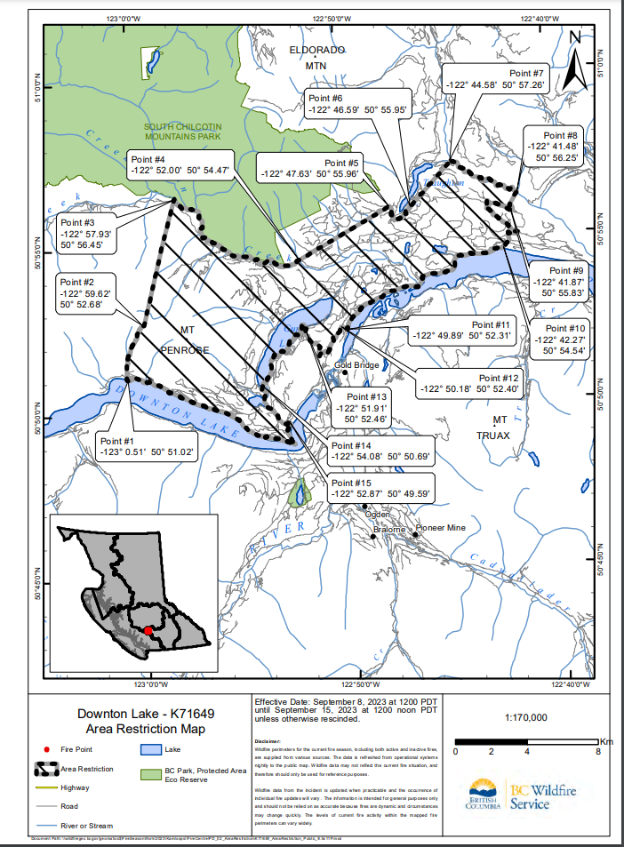
West Boundary: Commencing at Point #1 (50° 51.02′, -123° 0.51′) at the junction of Downton Lake and an unnamed tributary, travel north along the unnamed tributary to the headwaters of the unnamed tributary to Downton Lake (Point 2: 50° 52.68′, -122° 59.62′). Continue at a bearing of 15.76° for 7.28 km to Gun Greek (Point #3: 50° 56.45′, -122° 57.93′).
North Boundary: Commencing at Point #3 follow Gun Creek east to the junction with Freiberg Creek (Point #4: 50° 54.47’, -122° 52.00’). Take a bearing of 61.67° and travel 5.82 km to the resource road at Point #5 (50° 55.96′, -122° 47.63′). Travel east along the resource road until the end of the road on east side of Tyaughton Lake (Point #6: 50° 55.96′, -122° 47.63′). Take a bearing of 44.16°and travel 3.37km to the junction of Tyaughton Creek and the tributary of Tyaughton Creek (Point #7: 50° 57.26′, -122° 44.58′).
East Boundary: Commencing at Point #7, travel east along Tyaughton Creek to the junction with Liza Creek (Point #8: 50° 56.25′, -122° 41.48′). Take a bearing of 210.29° and travel .89 km to Point #9 (50° 55.83′, -122° 41.87′) at the resource road. Travel west then south along the resource road to the intersection with the tributary to Carpenter Lake. Then follow the tributary southerly to natural shoreline of the northern shore of Carpenter Lake (Point #10: 50° 54.54′, -122° 42.27′).
South Boundary: Commencing at Point #10, travel along the northern natural shoreline, west, to junction of shoreline and northern edge of land parcel 5926580 (Point #11: 50° 52.31′, -122° 49.89′). Continue west along parcel edge, through parcel 5926610 to the junction with the resource road at Point #12 (50° 52.40′,-122° 50.18′). Then travel west along resource road to Saddle Rd, then north to Mills Rd, west to survey parcel 5914710, and north to the natural shoreline of Gun Lake (Point #13: 50° 52.46′, -122° 51.91′). Travel south along the natural shoreline of Gun Lake to the southeastern edge of survey parcel 6485190 (Point #14: 50° 50.69′, -122° 54.08′). From here travel south along survey parcel 6485190, to the intersection with Gun Lake Road, then travel east and south along Gun Lake Road and Gun Lake West Road to the tributary of Downton Lake (Point #15: 50° 49.59′, -122° 52.87′). Travel south along the tributary to the natural northern shoreline of Downton Lake, then follow natural shoreline in a north and westerly direction back to Point #1.
The BC Wildfire Service would like to remind the public that while access to private residences is permitted, the public must remain out of active fire areas. Interference in these areas has a direct impact on operations and poses a safety risk to both the individual and to BC Wildfire Service personnel.
Failure to comply with Section 11 restricted area requirements may result in a violation ticket of $1,150.
Road closures and area restrictions are subject to change depending on fire activity. For the most current information please visit the bans and restrictions section of the BC Wildfire website for the Kamloops Fire Centre.
People can follow the latest wildfire news:
- on the free BC Wildfire Service public mobile app, available for Apple (iOS) and Android devices
- on Twitter
- on Facebook
Contact:
Fire Information Officer
BC Wildfire Service
Bendor Range Complex
250-554-7178
Connect with the Province of B.C. at www.gov.bc.ca/connect.