The BC Wildfire Service web and mobile app, available on our website or for free download on Apple and Android devices, is a comprehensive hub for wildfire information across the province. This service allows the BC Wildfire Service to share relevant, accurate and timely information with the public. This information can be critical to safety and provides a platform to inform the public of wildfire activity throughout the province.
The web and mobile app is one of many avenues the BC Wildfire Service uses to keep partners and the public informed. Facebook, X (formerly Twitter), BCWildfire.ca and fire centre information lines are also available to access wildfire information.
Incident Updates
Through the web and mobile app, BC Wildfire Service has the ability to manually update incident details for any wildfire, not just Wildfires of Note as it was previously. Each wildfire in the province is equipped with its own fire number to provincially classify them and gives the incident its own URL that will not change or be deactivated. Additionally, you can set up to three saved locations for which you want to receive updates whether that is for fire information, bans and restrictions or evacuation orders and alerts.
For specific fires, the public can view incident details by selecting the incident and moving between the different tabs labeled “Details”, “Response”, “Gallery” and “Maps”. The information provided includes:
- Fire number
- First discovered and last updated
- Location
- Stage of control
- Suspected cause
- Incident contact information
- A detailed response page to inform about weather, fire behaviour, resources, etc.
- Evacuation orders/alerts
- Photos and videos
Wildfire perimeters are the outside edge or boundary of a fire or burned area. The web and mobile app “Map View” shows the estimated extent of the area burned at that time. The fire perimeter, size, and Stage of Control data is refreshed from operational updates from the ground when they become available and once inputted into the operational systems, the map will update every five minutes.
Development Improvements
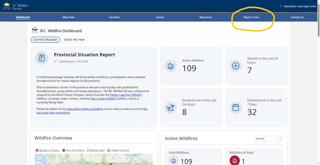
The current development improvements have equipped the web and mobile app with a comprehensive “Report a Fire” function to allow the public to easily report what they see. The public can call or go through a 15-minute process to report to the Provincial Wildfire Reporting Centre.
- On most devices, users will be able to add photos to the report, so our operations teams have a better understanding of the resources required for the situation.
- The reporting process now utilizes a compass, GPS and a map to allow for the precise location of the fire.
Through the program, users are prompted to:
- estimate the size of the fire
- identify the colour of the smoke
- if there are any signs of response
- if there are visible flames, what appears to be burning
- if there is anything at risk
- state if the fire appears to be spreading
The map has improved in ways to increase accessibility and clarity. The fonts, roads, and other features are clear and easier to read. The search function allows the public to search by place name, address, fire name or number, or evacuation. Additionally, the map has multiple layer filters to display popular needs including wildfires, evacuations, fire bans, area restrictions, smoke forecasts, fire danger and more. Finally, a legend increases accessibility by allowing users to interpret information more easily.
The dashboard allow the public to view updated and accurate information regarding fires in the province. The public can view general information about the entirety of the province, or specific fire centres.
The dashboard view provides the following information:
- number of active wildfires and wildfires declared out
- stages of control throughout the province
- evacuation alerts/orders for the province
- resources deployed throughout the province
- fire bans
Additional Resources
The BC Wildfire Service web and mobile app highlight preparedness tools for the public to utilize to prepare for the upcoming wildfire season. The app will effectively prepare the public for potential emergency situations, by providing access to clear and reliable information. Visit the BC Government’s news release highlighting tools for emergency preparedness to learn more about ways to prepare for the upcoming season.
In addition to utilizing the desktop version, be sure to download the mobile app for the most timely and accurate information regarding wildfires in the province. Prepare for the upcoming fire season by following guidelines of fire safety and contributing to FireSmart efforts. The app is available on the Google Play Store for Android, and the App Store for Apple. Help us help you by remaining FireSmart this season.
For further detail, see the web and mobile app reference guide.
Contact:
Provincial Fire Information Officer
BC Wildfire Service
250-312-3051
FIREINFO@gov.bc.ca