British Columbia is a diverse province with many different terrain types and topographic features, including cascading mountain ranges, ancient glaciers, semi-arid deserts, bountiful agricultural lands, boreal forests, rainforests, mighty rivers, thousands of lakes and the vast Pacific Ocean.
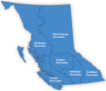
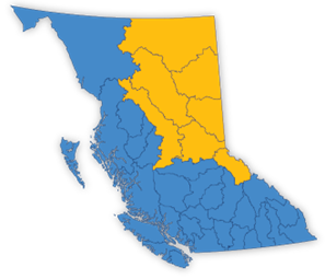
B.C. is divided into six fire centres: Cariboo, Coastal, Kamloops, Northwest, Prince George and Southeast. Each Fire Centre provides administrative, aviation and wildfire suppression services to all regions within their area of operation. Fire centres are staffed by wildfire officers, dispatchers, firefighters and support staff coordinating wildfire prevention, detection and suppression activities.
Each fire centre is divided into zones; within each zone, there are one or more initial attack bases. Initial attack bases are strategically located to provide balanced coverage throughout the province. When a new fire starts, firefighters are dispatched from their base at the direction of wildfire officers at a zone or fire centre.
The Cariboo Fire Centre (CaFC)
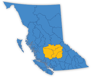
The Cariboo Fire Centre is based out of Williams Lake. It covers an area of about 8.25 million hectares, stretching from Loon Lake in the south to just north of Quesnel at the Cottonwood River. East to west, the centre stretches from the eastern edge of Wells Gray Provincial Park to the western boundary of Tweedsmuir Provincial Park.
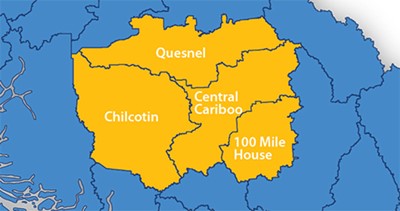
In the Cariboo Fire Centre, there are four zones: Central Cariboo zone with a base in Williams Lake, Quesnel zone, 100 Mile House zone and the Chilcotin zone with a base in Alexis Creek. Cariboo Fire Centre is home to several initial attack crews, the Vesta Unit Crew in Williams Lake, the Blackwater Unit Crew in Quesnel, the Ravens Unit Crew in Alexis Creek and the Stormriders Unit Crew in 100 Mile House.
The geography within Cariboo Fire Centre is remarkably diverse. It ranges from sand dunes, grasslands and rolling hills of the Fraser Plateau to the steep, densely wooded slopes of the Cariboo Mountains. The Fraser Plateau is sheltered from weather systems by the Coastal Mountain Range. This creates a dry belt, causing higher temperatures and lower precipitation levels, often persisting well into September and October. Fuel types in this area generally consist of Douglas fir, Lodgepole pine, spruce, open grass and beetle kill pine. Areas east of the plateau are in more of a wet belt, typically experiencing lower temperatures and more precipitation. The fuel types are mainly douglas fir, cedar, hemlock, spruce, lodgepole pine, and deciduous mix.
The Cariboo Fire Centre works closely with 16 First Nations, four regional districts and several municipalities to communicate and coordinate emergency response and wildfire risk mitigation projects. Within the Fire Centre is Tŝilhqot’in (Xeni Gwet’in) Declared Title Area. This land is governed by the Tŝilhqot’in People of Xeni Gwet’in. The 2018 tripartite Collaborative Emergency Management Agreement (CEMA) between the Tŝilhqot’in National Government and the governments of British Columbia and Canada was renewed in 2022 for five years. The CEMA creates a structure for collaboration to ensure that Nations are at the table and informing decisions that affect them, their families and their territories while prioritizing the importance of cultural safety and Indigenous knowledge in wildfire and emergency management.
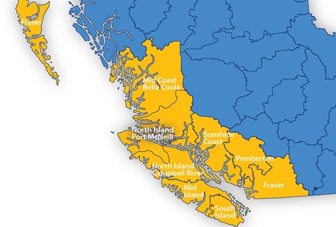
The Coastal Fire Centre (CoFC)

Spanning over 13.0 million hectares of extremely varied topography, the Coastal Fire Centre covers the area west of the height of land on the Coast Mountain range from the U.S.A./Canada border at Manning Park to the northern border of South Tweedsmuir Park, including the Lower Mainland, Sunshine Coast, Vancouver Island, Gulf Islands and Haida Gwaii. It contains 85 per cent of B.C.’s population. There are six zones within the Coastal Fire Centre: Fraser, Pemberton, Sunshine Coast, South Island, Mid Island and North Island/Mid-coast.
It also includes 130 local fire departments, 12 regional districts and 77 local governments. It lies partly or wholly in the traditional territories of approximately 110 First Nations.
Much of the terrain is rugged, steep and breathtakingly beautiful. Transportation to fires can be by ground, air or water. Staff have had plenty of experience using boats in firefighting efforts, as many islands make up its jurisdiction. Vegetation includes western hemlock, douglas fir, red cedar and mountain hemlock. In addition, two invasive species – broom and gorse – cause fire behaviour and control concerns.
The Kamloops Fire Centre (KFC)
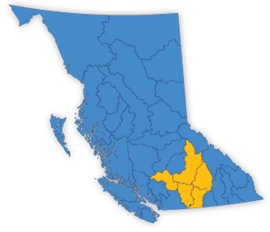
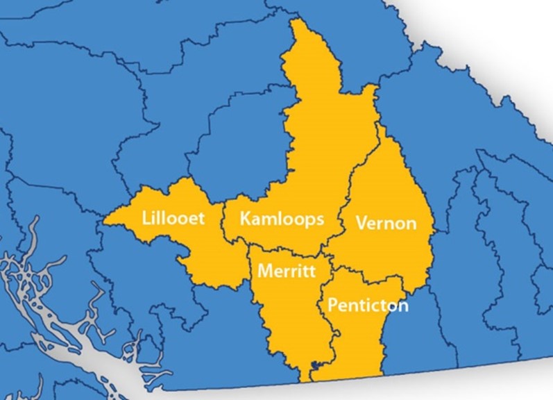
The Kamloops Fire Centre extends from the northern border of Wells Gray Provincial Park to the U.S. border in the south and from the Bridge River Glacier west of Gold Bridge to the Monashee Mountains east of Lumby and is roughly 7.1 million hectares in size. KFC comprises five zones: Kamloops, Vernon, Penticton, Merritt and Lillooet. In peak season, the centre has almost 400 staff members, including 38 initial attack crews and seven unit crews. In addition, the Provincial Rapattack program operates out of the Kamloops Fire Centre from their base in Salmon Arm. Rapattack, among many other resources, is utilized to action incidents where remote access will unreasonably delay response. They are also able to provide first aid and medevac support.
Kamloops Fire Centre typically experiences hot and dry weather, and it is common to have extended periods of temperatures between 35-40 C and with little to no rain. Geographically, the interior consists of steep terrain, temperate rainforests, and grasslands. Only one per cent of B.C. consists of grasslands, and most of those grasslands fall within Kamloops Fire Centre boundaries. The grasslands are also home to 30 per cent of B.C.’s species at risk.
With some of the largest populations in the interior of B.C., there is increased potential for wildfires in the urban interface. Typically, 25 per cent of the fires across the province each year are in the Kamloops Fire Centre.
The Northwest Fire Centre (NWFC)
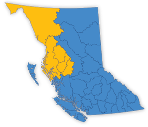
The Northwest Fire Centre covers about a quarter of British Columbia geographically. From the Pacific coast and Prince Rupert in the west, east to Endako, and from the Yukon border to Tweedsmuir Park. It is approximately 24.3 million hectares in size. The region has a diverse geography and landscape, featuring mountain ranges, glacier plateaus, coastal islands, fjords, estuaries and numerous lakes and rivers. The Northwest Fire Centre supports four zones: Cassiar, Skeena, Bulkley and Nadina.
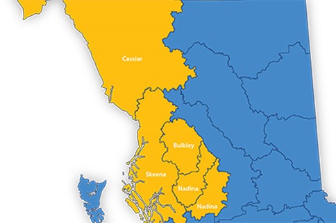
There are fire bases in Burns Lake, Telkwa, Terrace, Houston, Hazelton and Dease Lake. Firefighters can also be staged out of Atlin and Watson Lake if the potential for fire activity is high enough. There are 11 initial attack crews and four unit crews: Burns Lake Unit Crew, Telkwa Rangers, Hazelton Rainmakers and the Terrace Firebirds.
The Prince George Fire Centre (PGFC)
The Prince George Fire Centre oversees wildfire management in the northeastern portion of the province, an area totaling 33.6 million hectares, over one-third of the entire Province. The richness and diversity of the region’s landscape is illustrated by its boundaries which extend from the borders of the Yukon and Northwest Territories in the north to Tweedsmuir Provincial Park, Cottonwood River and Robson Valley in the south, and from the Alberta border in the east to the Skeena Mountains in the west. The Prince George Fire Centre supports eight fire zones: Fort Nelson, Fort St. James, Fort St. John, Dawson Creek, Vanderhoof, Prince George and Robson Valley.
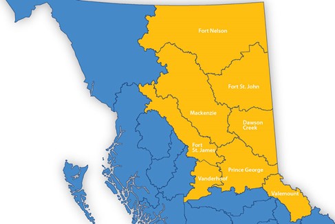
The provincial Parattack program is based out of the Fort St. John and Mackenzie zones.
Largely rugged and remote, the region is home to subalpine fir, interior cedar-hemlock, boreal and sub-boreal spruce forest ecosystems and unique wetlands known as muskegs. In addition, the Prince George Fire Centre is home to B.C.’s largest body of freshwater, Williston Lake, covering an area of 1,761 square kilometres.
There are 44 initial attack crews and four unit crews in the Prince George Fire Centre. Unit crews include the Prince George Firehawks, VanJam Titans, the Mackenzie Mack and the Fort St. John Rhinos.
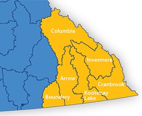
The Southeast Fire Centre (SEFC)
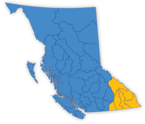
The Southeast Fire Centre is 8.2 million hectares in size and encompasses the area extending from the U.S.A border to Mica Dam and from the Okanagan Highlands and the western side of the Monashee Mountains to the B.C./Alberta border. The centre is broken up by a series of mountain ranges: the Monashees, Selkirks, Purcells and the Rockies. Between these large mountain ranges are deep valleys, where bustling communities lie, including Fernie to the east, Golden and Revelstoke to the north and as far west as Rock Creek. The Southeast Fire Centre supports six fire zones: Columbia, Boundary, Arrow, Kootenay, Invermere and Cranbrook.
The climate in the Southeast Fire Centre varies from a wet climate in the North to a dry climate in the Okanagan and southwest regions. The mountainous terrain can experience high temperatures in the summer and very low temperatures in the winter. The vegetation across the Southeast Fire Centre is very diverse and includes many species of large timber and grasslands.
Of the Province’s six Fire Centres, the Southeast Fire Centre historically experiences the second highest annual fire starts, over 75 per cent of which are attributed to lightning.
The Southeast takes preparation seriously, and many communities are banding together to FireSmart their local areas. Provincially, over half of the approved communities in the FireSmart Neighbourhood Recognition Program are in the Southeast, with an impressive 59 communities.