Anticipating the fire season: key factors and expectations
Wildfire season is underway across Canada. Here in B.C., we are constantly monitoring the current and forecast conditions to support longer term wildfire response planning. Our Summer Seasonal Outlook captures what we expect to see during the peak of the wildfire season based on the data we currently have available.
We consider three key factors to forecast the core wildfire season: drought levels, overwinter snowpack and periods of prolonged heat without rain in June. Watch the video to hear more on what we predict for summer 2025 from the Superintendent of the Predictive Services Unit, Neal McLoughlin.
Regional drought and Fire Danger Indices
Multi-year drought conditions continue to persist in the northeast corner of the province and parts of the Central Interior. These deep drought conditions have been ongoing since 2022 in some regions and continue to pose challenges to wildfire response.
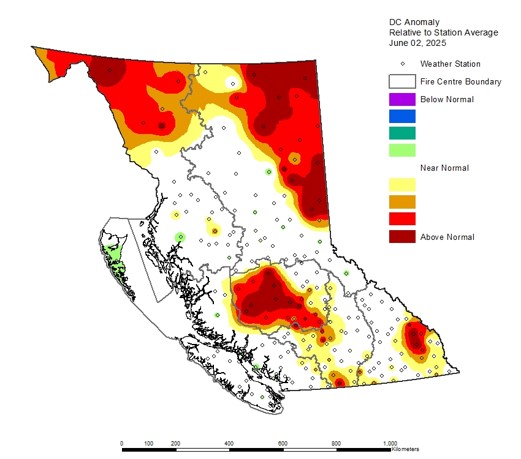
Drought Codes in the northeast where we have seen persistent year-over-year dryness are well above average, but this is also the case for parts of the far northwest, the central Cariboo and areas of the southeast along the Rocky Mountain Trench.
For firefighters on the ground, elevated Drought Codes mean a more dangerous work environment and slower suppression operations, as deep digging and water application are necessary to extinguish fires under these conditions.
Snowpack’s impact on wildfires
Temperatures were near normal for most of B.C. through the spring. These cooler conditions helped to slow snow melt rates and even supported additional snowfall in the alpine in some areas. While the northeast corner of the province was warmer than normal, we can contrast the current snowpack levels (80-89% of normal) with the situation at this time last year (50-58% of normal).
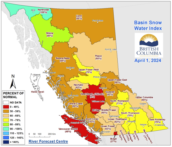
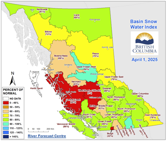
Currently, provincial snowpack is below normal with about 61% remaining across the province, on average. This lower level of snowpack means less surface runoff, lower stream flows, and ultimately, forest fuels that dry out more quickly, becoming more prone to ignition.
Spring precipitation
We experienced wetter-than-normal conditions up and down the coast in May, but this was contrasted with drier-than-normal conditions in the Peace Country and Fort Nelson regions. According to Environment and Climate Change Canada, Fort Nelson recorded their driest spring on record since 1938, and Fort St. John saw their second driest spring since 1910.
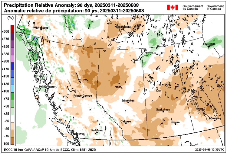
Based on current modelling, we anticipate a drier June than usual, building on the warming, drying trend we have seen impact the northeast and many parts of the Interior already this spring. However, accurately predicting precipitation levels in the longer term is challenging, and this outlook could change.
Impacts of overwintering fires
The impact of overwintering fires is also an important factor in the kind of wildfire activity we can expect this summer.
We continue to respond to overwintering fires from the 2023 and 2024 wildfire seasons in the northeast. These fires move underground and slumber throughout the winter months, resurfacing when conditions warm up in the spring. Learn more about overwintering fires in the Fort Nelson Zone and the response actions taken to mitigate them this winter.
Current status of overwintering fires and area burned
Overwintering fires in the northeast, particularly in the Fort Nelson and Fort St. John areas, have been a focus this spring, with firefighters, aviation resources, structure protection specialists, heavy equipment operators and incident management professionals engaged in response. As the weather gets warmer, we anticipate these fires will continue to pose a challenge to response efforts.
So far this year, 563,890 hectares have burned in B.C., with 562,221 hectares (99 per cent) of this area within the Prince George Fire Centre. On the same date in 2024, 491,888 hectares had burned provincewide, and we can compare this with the 10-year average for the same period: 118,414.5 hectares.
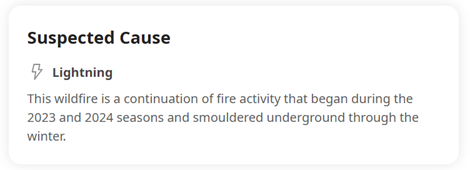
On our public map and mobile app, fires that are the result of overwintering are labelled with the following information under their Suspected Cause: “This wildfire is a continuation of fire activity that began during the 2023 and 2024 seasons and smouldered underground through the winter.”
Fire season outlook and historical context
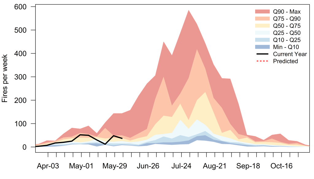
So far this year, fire activity has hovered around average compared with historical data, but in the last two weeks we’ve seen our activity increase to well above average. Given the underlying drought conditions, the lack of snowpack and low likelihood of additional precipitation, we expect to see an increase in the already significant fire behaviour in the northeast.
Summer outlook
While it is not possible to produce long-range precipitation forecasts with a high degree of confidence, our current forecast shows we will likely see a warmer and drier June than usual. Typically, June can be a cool and showery time of year in B.C., but we do not expect significant amounts of rain this year. Currently, there is no indication of sufficient rainfall to alleviate elevated drought conditions, particularly in the northeast of B.C.
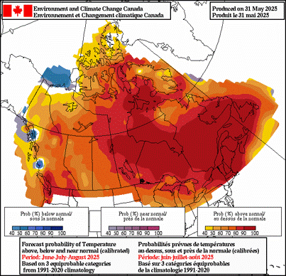
Guidance from Environment and Climate Change Canada (ECCC) is also indicating a high probability of above-normal temperatures for the remainder of the summer.
Summary
As we approach the core of the 2025 fire season, we expect the underlying multi-year drought conditions in the northeast will persist. Many overwintering fires that smouldered through the winter have re-intensified under dry conditions and heightened winds. With the warm, dry outlook, other fires still have the potential to re-invigorate through the beginning of summer. Long-range guidance suggests a warmer-than-normal summer across much of B.C. The amount of rain required to mitigate the current drought is unlikely to occur.
Given these conditions, there is an increased likelihood of large, challenging fires in the northeast corner of B.C. again this summer., as well as other dry pockets in the Southwestern Interior and Chilcotin regions.
While current conditions indicate continued aggressive fire behaviour in northeast B.C., along with other drought-stricken areas, the longer-term forecast will depend heavily on the amount of precipitation we receive in the weeks ahead.
Do you part and stay informed about the current wildfire situation: