Heading into the 2026 wildfire season, fuel conditions across British Columbia reflect a combination of last summer’s Drought Code, winter precipitation events and recent warm and dry conditions. These factors have influenced moisture levels across the landscape and will shape wildfire potential across the province in the coming months. Watch BC Wildfire Service’s lead fire weather forecaster, Matthew MacDonald, present the outlook below.
Highlights of the seasonal outlook include the following:
- Wetter-than-normal conditions were recorded for B.C. in December prior to freeze-up which helped alleviate drought conditions for the majority of B.C., including the Coast and the Southeast. March was another wet month which helped to further alleviate drought concerns in many regions of the province.
- Despite higher than average rainfall during the 2025 summer, the northeast region of B.C. remains an area of concern given the ongoing, multi-year drought conditions
- Moderate drought conditions also exist in the western parts of the Cariboo Fire Centre (Chilcotin) and the majority of the Kamloops Fire Centre
- Higher-than-normal winter freezing levels have resulted in record low snow at valley bottom. This increases the likelihood of early season grass fires in Interior valleys
- The severity of the 2026 wildfire season will largely depend on the amount and frequency of spring (May and June) precipitation
- Unfortunately, there is little or no skill in long range precipitation forecasting so stay tuned via the BC Wildfire Service app and social media
Review of fuel conditions from late fall 2025
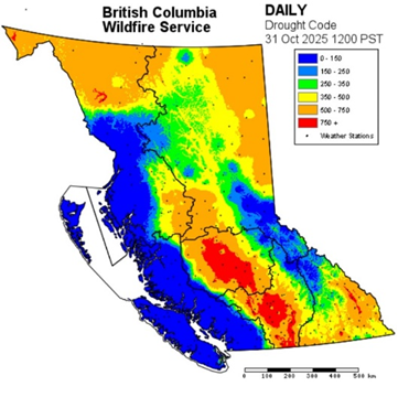
The summer of 2025 was notable for persistent westerly flow and multiple weather systems moving in from the Pacific. Westerly flow patterns keep regions in the lee of the Coastal Mountain range subsident and dry. Drought Code measures the moisture content of organic layers at moderate depth and represents smoldering in deep duff layers and large logs. Higher Drought Code values indicate increased fire hazard. The elevated drought conditions can support the potential for very large fires and make for challenging fire suppression later in the season. Examples include the western Cariboo stretching west into the Chilcotin that concluded the season with exceptionally high Drought Code.
The Kamloops Fire Centre experienced a very dry summer, while the northeast portion of the province saw some improvement in comparison to the last four to five summers. Both Fort St. John and Fort Nelson received near or slightly higher-than-average rainfall in both June and July, something we had not observed in several summers.
Over-winter precipitation and change in moisture
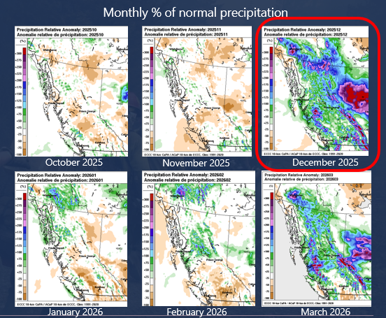
Throughout October and November, below-normal precipitation was recorded over central, northeastern and southern B.C. Temperatures were quite mild with very little frost or snow in the B.C. Interior. Active storm patterns brought several atmospheric rivers to B.C. in December, delivering copious amounts of precipitation. Given the mild and frost-free conditions, vegetation was able to absorb the abundant moisture and decrease Drought Codes. Regions that saw the greatest reduction in drought conditions include the coastal and southeastern regions of the province.
Heading into the core of winter, the entire province experienced above-normal temperatures and drier-than-normal conditions in January and February. In fact, for several Interior locations, it was the warmest winter in recorded history since the late 1800’s. The latter part of the winter saw storms confined to northern regions.
Snowpack overview
Areas of below-normal snowpack show early concerns for drought conditions which could amplify fire behaviour this spring and summer. Higher-than-normal winter freezing levels have resulted in record low snow at valley bottoms, increasing the likelihood of early season grass fires in the Interior valleys. Below-normal regions include Vancouver Island, the South Coast, the Chilcotin, the Lower Fraser, the Lower and South Thompson regions and the Okanagan.
Current sea surface temperatures
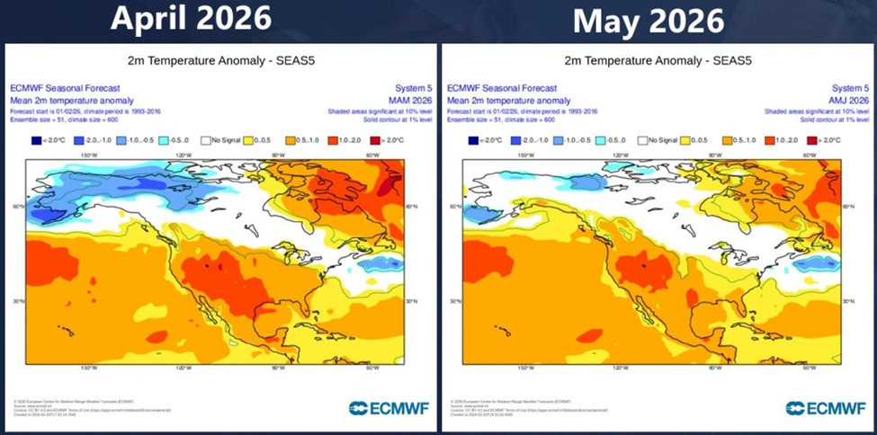
The ocean plays a significant role in driving mid-to-long range weather forecasts. Warmer-than-normal sea surface temperatures offshore contributed to higher freezing levels earlier this season. Meanwhile, La Niña, which is defined by below normal sea surface temperatures in the equatorial Pacific, persisted into January. As of mid-March 2026, the equatorial Pacific is transitioning from declining La Niña conditions toward neutral El Niño-Southern Oscillation (ENSO) conditions. The latest seasonal forecast guidance favours a transition towards strong El Niño conditions beginning in June-July. While El Niño will increase the chances of a warmer than normal summer, the correlation between El Niño’s and fire activity in western Canada remains inconclusive.
Spring 2026: start-up conditions
High Drought Code values indicate an increased potential for extreme fire behaviour and can make wildfires more difficult to control. Even with normal spring precipitation, areas affected by multi-year drought, particularly the Northeast, the Chilcotin and the South Thompson, are expected to carry elevated Drought Code values into spring 2026. Moderate drought conditions also persist in the Cariboo Fire Centre and the Kamloops Fire Centre more broadly. The overall severity of the 2026 wildfire season will largely depend on precipitation amounts in May and June.