Fall 2024: Continued persistent drought
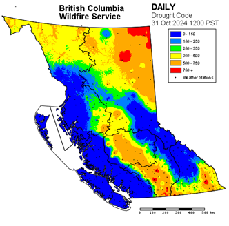
At the end of the 2024 wildfire season, we continued to see the impacts of multi-year drought conditions, which persisted into the fall over the Northeast corner of the province. Several months of below-normal precipitation in the southern Nechako and Chilcotin plateau regions led to increased drying in those areas as well. These deep drought conditions were evidenced by fires that burned well into the fall in the Northeast and in the southern Nechako region.
As a result, the Northeast corner of the province once again saw large wildfires continue to smoulder underground over the winter. These overwintering fires are now, in some areas, smouldering and producing visible smoke.
BC Wildfire Service personnel in the Prince George Fire Centre are currently monitoring existing fires as conditions allow and have prioritized response objectives. We have also met with local government and interest groups to discuss holdover response in the region and address community concerns. You can read more about overwintering fires and our continued response through winter 2025 here.
Winter 2025: Unusual precipitation patterns
Above-average fall precipitation in southern B.C. helped to relieve drought in the Coastal and Southeast Fire Centres. While B.C. was forecast to experience La Niña conditions, which typically favour cooler temperatures and increased precipitation, the entire province experienced an abnormally dry January and drier-than-usual February.
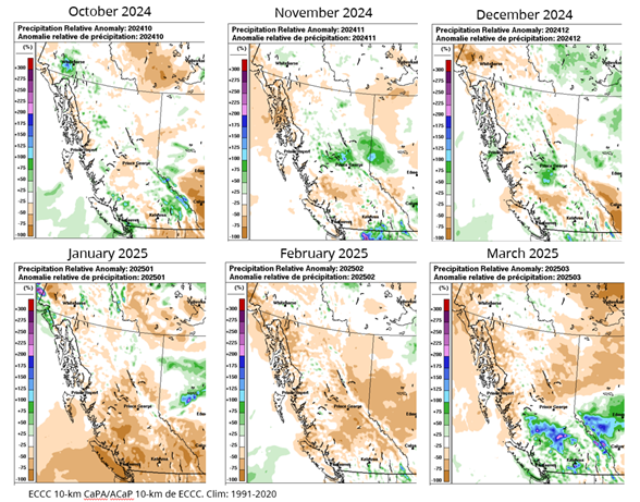
As a result of this trend, snowpack growth was limited during January and February. However, precipitation increased significantly in March across southern B.C., with 100-200% of normal amounts recorded. This supported the development of a more robust snowpack in the south, however mountain ranges in the north saw limited accumulations.
Snowpack at higher elevations is an important factor in lightning-caused wildfires. When mountain tops are covered with snow, vegetative fuels cannot ignite, reducing the risk of wildfire starts in remote areas. We continue to carefully monitor snowpack and precipitation as we move into the spring.
Spring 2025: Outlook
With spring’s arrival, the weak La Niña conditions B.C. experienced through the winter have faded, ushering in warmer-than-usual temperatures across much of the province. Many valley bottoms in the Southern Interior are now free of snow, allowing grasses and fine fuels to quickly dry out, making them more available for burning.
This marks the beginning of the annual phenomenon known as Spring Dip. Spring Dip describes the decrease in foliar moisture, or the amount of moisture in the needles of coniferous trees. It occurs in the period shortly after the snow has melted, but before vegetation begins to green up. Trees, and especially conifers, also have a low moisture content, which makes them especially vulnerable in early spring.
We anticipate above-average levels of precipitation throughout early April over Coastal and Central B.C. This rain is helping to reduce underlying dry conditions across the Southern Interior, delaying the onset of increased wildfire hazard.
We expect ongoing drought to continue to persist across the Northeast and in the Cariboo, even if these areas receive average or higher levels of precipitation. However, drought conditions have improved compared to spring 2024, thanks to overwinter precipitation and spring rains.
Watch Neal McLoughlin, Superintendent of Predictive Services for the BC Wildfire Service deliver a brief presentation on the spring wildfire outlook. This spring readiness call also includes presentations by Minister of Emergency Management and Climate Readiness, Kelly Greene; Ravi Parmar, Minister of Forests; and Randene Neill, Minister of Water, Land and Resource Stewardship, for an update about seasonal emergency preparedness featuring presentations on freshet, wildfire and drought outlook.
Summer 2025: Long-range forecast
Forecasters expect warmer-than-usual temperatures as we continue into spring, coupled with the potential for above-average precipitation over Coastal and Central B.C. That above-normal precipitation could help to mitigate the drying impacts of warmer temperatures and continue to promote early green up of vegetation.
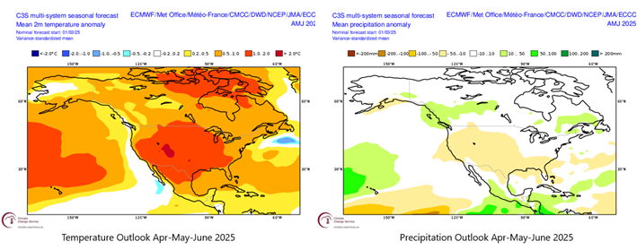
Importantly, May and June are typically the rainiest months in the B.C. Interior. The amount and duration of rain events during this period will influence the length and intensity of the core wildfire season.
Stay tuned for the Summer Outlook, which will be released in June 2025.