Watch BC Wildfire Service’s Lead Fire Weather Forecaster, Matt MacDonald, and Superintendent of Predictive Services, Neal McLoughlin, share an update on the heatwave between late August and early September, the affects it had on indices, fuels and fires, and what the long range guidance suggests for the fire season heading into the fall.
Recent conditions and fire activity
During August, warmer and drier than usual conditions prevailed across most of the province. The hot and dry weather has intensified drought conditions heading into fall.
A late season heatwave from August 21 to September 5 provided accelerated drying of B.C.’s forests and fuels. Throughout that same period, 115 daily maximum temperature records were broken across the province. In the midst of the prolonged heat was a multi-day dry lightning event between August 28 and 31. In that time, 5,925 lightning strikes were recorded and 88 new fires were ignited across central and southern B.C.
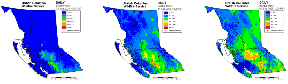
The heat and drying affected fuels, increasing fire danger ratings and Build-Up Index (BUI) values. The BUI represents the total amount of fuel readily available to burn. The charts below show the change in BUI values from August 22 to August 31 to September 9. Areas on the charts showing green, yellow, orange and red represent where there are fuels that are increasingly receptive to lightning ignition. The high BUI values were not unprecedented; however, the upwards trend is contrary to the usual downturn in early September.
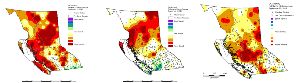
The lack of moisture throughout the heatwave also elevated the Drought Code (DC). The DC is a measure of the moisture levels in deep organic layers of the forest floor and large woody debris. Higher DC values correspond with lower fuel moisture. Dry fuels have a greater ability to burn which is what has been experienced over the last four weeks. Prior to the heatwave, B.C. received semi-regular rainfall this summer, keeping fuels green and less susceptible to ignition. Northern B.C. in particular saw reduced and improved DC values when compared to 2023 and 2024 in the images below. Inversely, DC values are above average for this time of year throughout the Central Interior. Heading into the fall, the areas in the various shades of red are of concern.
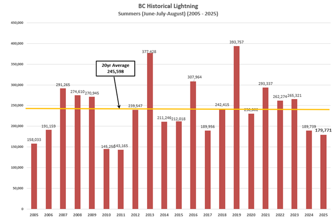
Lightning is a significant cause of wildfires in B.C. however this summer showed lower lightning activity than usual. From June to August, the total lightning strike count was 73 per cent of the 20-year average. While lightning itself is a concern with respect to new wildfire starts, a more important factor is when lightning coincides with increasingly dry conditions. The drier the conditions are, the more likely a lightning strike is to ignite a fire and grow quickly. To date, lightning has caused 57 per cent of the 1,269 wildfire starts, which account for 87 per cent of the total area burned in 2025.
Recent record-breaking heat and unseasonably dry conditions have supported extreme fire behaviour in the Chilcotin and western Cariboo regions. Extreme fire behaviour is typically associated with ridge breakdowns, cold fronts, and significant gusty winds. The extreme fire behaviour we’ve experienced over the last month has occurred under relatively light winds but due to the very dry conditions, fuels are burning quickly and intensely, challenging fire suppression. When strong gusty winds are present in these drought conditions, wildfires can easily spread 10 to 20 kilometres in one day.
Fall forecast
Summer-like conditions persist. Looking at projections for the next 30 days, warmer and drier than normal conditions are forecast for most of B.C. through September and into the beginning of October. The one exception is northwestern B.C. where cooler and wetter conditions are forecast. As for the South Coast, there is no clear signal for when the shift to a stormier fall-like pattern will occur.
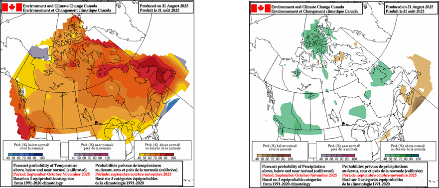
When looking at longer range forecasts into November, sea surface temperatures play an important role in driving weather patterns. Currently, the northern Pacific Ocean is carrying a significant amount of heat with sea surface temperatures two to five degrees warmer than average. This heat could provide added energy to typhoons, atmospheric rivers and more intense storms later this fall. The below chart shows how much warmer than normal the oceans are. For context, the temperature anomaly scale on this chart previously had a maximum of 2.5 degrees Celsius above and below normal whereas it has now been extended to 5.5 degrees Celsius in order to capture how warm the oceans are.

The below guidance from Environment and Climate Change Canada indicates a fair likelihood of above normal temperatures and weak probabilities of above normal rainfall for southern B.C. this fall. Until we receive prolonged measurable rainfall, fuels will remain receptive to ignition, well through September.
As fall approaches, thunderstorm activity decreases, leading to a steady decline in lightning-caused wildfires. Despite a lower likelihood of new lightning starts this fall, new human-caused wildfires remain a risk.
Fall 2025 fire activity is expected to be reminiscent of the 2022 fire season. In 2022, sustained warm and dry weather extended B.C.’s wildfire season well into the fall. Many areas of the province set temperature records, and accumulated rainfall amounts through September that were below normal levels. Similar to 2022, this fall is expected to be busier than normal due to the warm and dry outlook and elevated drought conditions throughout the Central Interior. Ongoing fire activity associated with wildfires that started in late August is of greatest concern.

Summary
A late season heatwave during late August and into early September increased the dryness of our fuels and drought code values across much of the province resulting in increased fire danger.
Long range guidance favours above seasonal temperatures along with limited precipitation to help alleviate these dry conditions.
The dry vegetation remains highly susceptible to ignition from human activity.
A longer lasting fire season is likely into the fall of 2025.
Fire danger remains high to extreme in the Cariboo and the Southwest Interior.
Under the warm and dry pattern, fires will have the potential to grow significantly in size under increasing winds.
An active prescribed fire season will be possible given the elevated fire weather indices.
Do you part and stay informed about the current wildfire situation
- Download the BC Wildfire Service App
- Follow us on Facebook and Instagram
- Watch our YouTube for wildfire updates and information