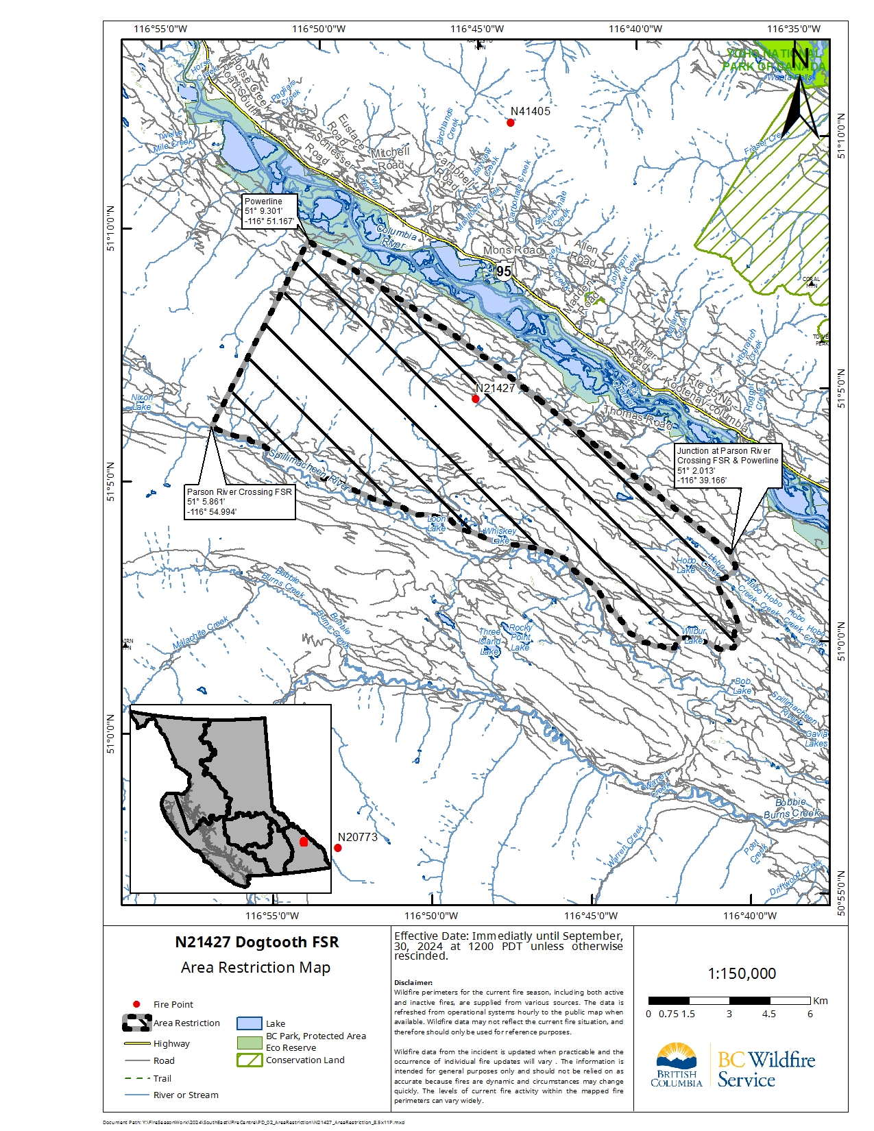
CASTLEGAR – The BC Wildfire Service continues to respond to the Dogtooth FSR wildfire (N21427), located about 24 kilometres southeast of the town of Golden and about 6 kilometres west of Highway 95. The size is estimated to be 133 hectares.
In the interest of public and responder safety, an area restriction is now in effect within the Dogtooth FSR area:
- Commencing at the junction of Parson River Crossing FSR & the powerline (51° 2.013′, -116° 39.166′),
- continuing along the Parson River Crossing FSR to coordinates (51° 5.861′, -116° 54.994′),
- crossing over the height of land directly northeast back to coordinates at the powerline (51° 9.301′, -116° 51.167′),
- following the powerline southeast back to the point of commencement at the junction of Parson River Crossing FSR & the powerline (51° 2.013′, -116° 39.166′).
Note: The Parson River Crossing FSR will remain open; entering into the restricted area off the FSR is prohibited.
- Under this Order and section 11(2) of the Wildfire Act, a person must not remain in or enter the restricted area, unless the person:
- first receives written authorization of an official designated for the purposes of the Wildfire Act, or enters the area only in the course of:
(a) travelling to or from his or her primary residence, that is not under an evacuation order;
(b) using a highway as defined in the Transportation Act;
(c) travelling as a person acting in an official capacity as defined in s.56 of the Wildfire Act; or
(d) travelling for the purpose of supporting wildfire suppression or enforcement patrol activities.
A detailed map of the affected area is available HERE.
Road closures and area restrictions are subject to change depending on fire activity. For the most current information please visit the bans and restrictions section of the BC Wildfire website for the Southeast Fire Centre.
The Southeast Fire Centre extends from the U.S. border in the south to Mica Dam in the north, and from the Okanagan Highlands and Monashee Mountains in the west, to the B.C.-Alberta border in the east.
To report a wildfire, unattended campfire or open burning violation, call 1 800 663-5555 toll-free or *5555 on a cellphone. For the latest information on current wildfire activity, burning restrictions, road closures and air-quality advisories, visit: http://www.bcwildfire.ca or download the BC Wildfire App free for Apple and Android devices.
Follow the latest wildfire news:
X (formerly Twitter) at: www.twitter.com/BCGovFireInfo
Facebook at: www.facebook.com/BCForestFireInfo
Contact:
Fire Information Officer
BC Wildfire Service
Southeast Fire Centre
250-318-7715
Connect with the Province of B.C. at www.gov.bc.ca/connect