CASTLEGAR – The BC Wildfire Service continues to respond to the Argenta Creek wildfire (N71058), located adjacent to the community of Argenta, on the north end of Kootenay Lake.
In the interest of public and responder safety, an amended area restriction takes effect August 6, 2024, at 12:00 noon (PDT) and remains in force until the earlier of 12:00 noon (PDT) on September 30, 2024, or until the Order is rescinded:
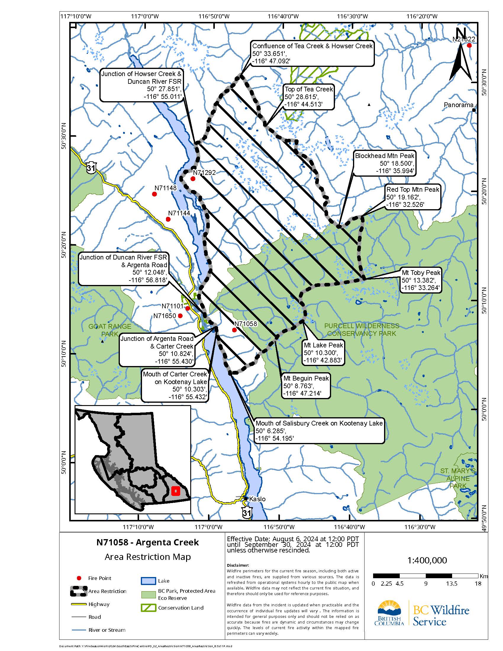
- Commencing at the mouth of Salisbury Creek on Kootenay Lake @ [50° 6.285′, -116° 54.195′],
- following along Salisbury Creek to the height of land and following height of land to Mt Beguin Peak @ [50° 8.763′, -116° 47.214′].
- Continuing along the height of land tying into Mt Lake Peak @ [50° 10.300′, -116° 42.883′],
- continuing along height of land tying into Mt Toby Peak @ [50° 13.382′, -116° 33.264′].
- Turning North continuing along height of land tying into Red Top Mtn Peak @ [50° 19.162′, -116° 32.526′],
- tying into Blockhead Mtn Peak @ [50° 18.500′, -116° 35.994′] and following height of land to the top of Tea Creek @ [50° 28.615′, -116° 44.513′].
- Following Tea Creek downslope to the mouth of Tea Creek on Howser Creek @ [50° 33.651′, -116° 47.092′],
- continuing Southwest down Howser Creek meeting up with the Duncan River FSR @ [50° 27.851′, -116° 55.011′].
- Following the Duncan River FSR South until the junction of Duncan River FSR & Argenta Road @ [50° 12.048′, -116° 56.818′],
- continuing along Argenta Road to the mouth of Carter Creek on Kootenay Lake @ [50° 10.303′, -116° 55.432′].
- Following the shoreline of Kootenay Lake South back to the point of commencement at the mouth of Fry Creek on Kootenay Lake @ [50° 3.524′, -116° 52.623′].
Under this Order and section 11(2) of the Wildfire Act, a person must not remain in or enter the restricted area without the prior written authorization of an official designated for the purposes of the Wildfire Act, unless the person:
Enters the area only in the course of:
- Travelling to or from his or her principal residence, that is not under evacuation an order;
- Travelling to or from his or her private or leased property for the purpose of accessing his or her secondary residence or recreational property, that is not under an evacuation order;
- Using a highway as defined in the Highway Act;
- Travelling as a person acting in an official capacity as defined in s.56 of the Wildfire Act;
- Travelling for the purpose of supporting wildfire suppression or enforcement patrol activities.
Failure to comply with Section 11 restricted area requirements may result in a violation ticket for $1,150.
A detailed map of the affected area is available here.
Road closures and area restrictions are subject to change depending on fire activity. For the most current information please visit the bans and restrictions section of the BC Wildfire website for the Southeast Fire Centre.
The Southeast Fire Centre extends from the U.S. border in the south to Mica Dam in the north, and from the Okanagan Highlands and Monashee Mountains in the west, to the B.C.-Alberta border in the east.
To report a wildfire, unattended campfire or open burning violation, call 1-800-663-5555 toll-free or *5555 on a cellphone. For the latest information on current wildfire activity, burning restrictions, road closures and air-quality advisories, visit bcwildfire.ca, the BC Wildfire Service web app or download the mobile app free for Apple and Android devices.
Follow the latest wildfire news:
• X at: x.com/BCGovFireInfo
• Facebook at: facebook.com/BCForestFireInfo
• BC Wildfire Service mobile app available for: Apple and Android
Contact:
Fire Information Officer
BC Wildfire Service
Southeast Fire Centre
250-318-7715
Connect with the Province of B.C. at www.gov.bc.ca/connect