CASTLEGAR – The BC Wildfire Service continues to respond to the Ravenshead wildfire (N21610), located about 20 kilometres east of the District of Invermere and about 16 kilometres northeast of Highway 93/95.
The area restriction in place for this wildfire is being reduced in size, but there is still a continued need to protect the public in areas where ongoing fire suppression activities are taking place.
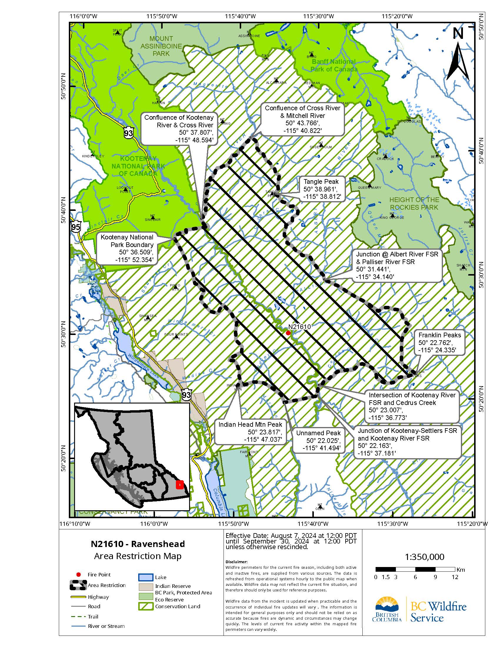
In the interest of public and responder safety, an amended area restriction takes effect August 7, 2024, at 12:00 noon (PDT) for the Ravenshead area, and remains in force until the earlier of 12:00 noon (PDT) on September 30, 2024, or until the Order is rescinded:
- Commencing at Indian Head Mtn Peak @ [50° 23.817′, -115° 47.037′],
- Follow height of land East/Southeast to Unnamed Peak @ [50° 22.025′, -115° 41.494′],
- Continuing East down slope to the junction of Kootenay-Settlers FSR and Kootenay River FSR @ [50° 22.163′, -115° 37.181′],
- Following Kootenay River FSR north across Kootenay River to the intersection with Cedrus Creek @ [50° 23.007′, -115° 36.773′],
- Following Cedrus Creek East to height of land and following the height of land tying into Franklin Peaks @ [50° 22.762′, -115° 24.335′],
- Continuing North along the height of land crossing over the junction of Albert River FSR & Palliser River FSR @ [50° 31.441′, -115° 34.140′].
- Continuing North/Northwest tying into Tangle Peak @ [50° 38.961′, -115° 38.812′],
- Continuing along height of land to the confluence of Cross River & Mitchell River @ [50° 43.766′, -115° 40.822′].
- Turning South/Southwest following along Cross River to the confluence of Kootenay River & Cross River @ [50° 37.807′, -115° 48.594′],
- Meeting the outer boundary of Kootenay National Park.
- Following the outer boundary of Kootenay National Park to [50° 36.509′, -115° 52.354′],
- Turning South/Southeast following along the height of land tying into Indian Head Mtn Peak @ [50° 23.817′, -115° 47.037′].
Note: Travel along the Kootenay Forest Service Road (FSR) is permitted. Travel on the Ravenshead and Palliser FSR’s is not permitted.
Under this Order and section 11(2) of the Wildfire Act, a person must not remain in or enter the restricted area without the prior written authorization of an official designated for the purposes of the Wildfire Act, unless the person:
Enters the area only in the course of:
- Travelling to or from his or her principal residence, that is not under evacuation an order;
- Travelling to or from his or her private or leased property for the purpose of accessing his or her secondary residence or recreational property, that is not under an evacuation order;
- Using a highway as defined in the Highway Act;
- Travelling as a person acting in an official capacity as defined in s.56 of the Wildfire Act;
- Travelling for the purpose of supporting wildfire suppression or enforcement patrol activities.
Failure to comply with Section 11 restricted area requirements may result in a violation ticket for $1,150.
A detailed map of the affected area is available here and below.
Road closures and area restrictions are subject to change depending on fire activity. For the most current information please visit the bans and restrictions section of the BC Wildfire website for the Southeast Fire Centre.
The Southeast Fire Centre extends from the U.S. border in the south to Mica Dam in the north, and from the Okanagan Highlands and Monashee Mountains in the west, to the B.C.-Alberta border in the east.
To report a wildfire or open burning violation, call 1 800 663-5555 toll-free or *5555 on a cellphone. For the latest information on current wildfire activity, burning restrictions, road closures and air-quality advisories, visit: bcwildfire.ca, the desktop Wildfire Map or download the BC Wildfire App free for Apple and Android devices.
Follow the latest wildfire news:
• X at: x.com/BCGovFireInfo
• Facebook at: facebook.com/BCForestFireInfo
• BC Wildfire App available for: Apple and Android
Contact:
Fire Information Officer
BC Wildfire Service
Southeast Fire Centre
250-318-7715
Connect with the Province of B.C. at www.gov.bc.ca/connect