QUESNEL – The Quesnel Natural Resource District, in partnership with the Cariboo Regional District, the City of Quesnel and the Ministry of Environment and Parks, will be conducting a Wildfire Risk Reduction project in the community of Kersley, south of Quesnel.
When and where
- Work on this project may start as early as February 1, 2026, continuing into April of 2026.
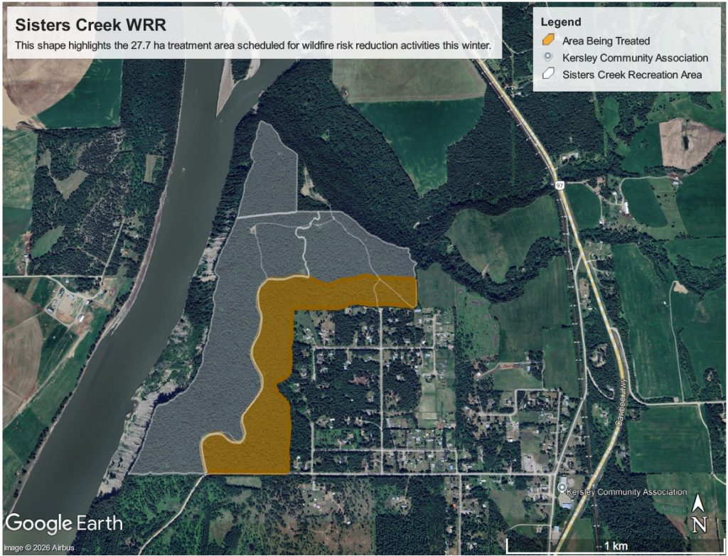
- The treatment area will cover a total of 27.7 hectares located approximately 20 kilometers south of Quesnel, at the end of Arnoldus Road in Kersley.
What to expect
- Contract crews will be using both manual and special mechanical methods to create gaps between the larger, mature timber and the smaller understory trees.
- Overstory trees will be retained as much as possible while creating spaces in the tree canopy, by targeting trees with defects or poor health first and leaving the healthiest. Understory trees, smaller than 12.5 centimetres in diameter will be thinned and branches on remaining trees will be pruned up to 3 metres, or up to half of their height, whichever is less.
- Wildlife trees, deciduous trees and coarse woody debris will be retained to protect recreational trails, wildlife habitat and community values.
- Piles no larger than two metres by three metres will be created. The piles will be burned when conditions are appropriate and burn scars will be grass-seeded after completion.
- Contract crews will ignite burn piles using hand torches under favourable conditions and will closely monitor all fire activity. Burning may occur over multiple days, as weather and site conditions allow.
- Personnel will remain on-site each day to ensure fires are controlled and will only leave once the fires have safely burned down and no longer pose a risk of spreading.
- Fires will continue to be monitored and extinguished once burning is complete.
- Smoke and flames will be visible to Kersley residents and surrounding communities as well as motorists travelling along Highway 97.
- This project does not include private property.
- While burning is underway some public trails will be restricted, signage will be placed on the trails as needed.
Objectives of this Wildfire Risk Reduction project
- Reduce wildfire risk around Kersley and surrounding areas.
- Strategically remove fuels, reducing the ability of wildfire to spread from ground to canopy and reducing overall intensity of a potential wildfire.
- Increase the effectiveness of recently completed fuel treatments and other previous Wildfire Risk Reduction projects within the Sisters Creek Recreational Area.
Learn more
Fire is a natural process in many of B.C.’s ecosystems. The BC Wildfire Service works regularly with land managers to undertake fuel management activities, including the use of prescribed burns and wildfire risk reduction projects, to help reduce the severity of future wildfires and related threats to communities
Minimizing health impacts from smoke
Exposure to smoke from wildfires or prescribed burning can irritate eyes and respiratory tracts and worsen pre-existing lung and heart conditions. If your area is impacted by smoke:
- Manage pre-existing conditions, and seek medical care if you have severe symptoms.
- Reduce the length and intensity of outdoor activities.
- Run portable air cleaners with windows and doors closed. Both commercial and home-made units (https://rb.gy/90uh5s) can be effective if operated properly.
Learn about protecting your health from smoke online: http://www.bccdc.ca/health-info/prevention-public-health/wildfire-smoke
Contact
Vincent Luu, RPF
Land and Resource Specialist
Quesnel Natural Resource District
Phone: 250-992-4400
Email: Land.Resources.DQU@gov.bc.ca
Connect with the Province of B.C. at www.gov.bc.ca/connect